U.S. Interior Highlands
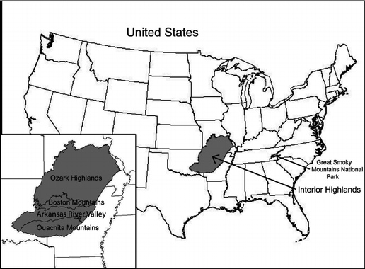
The U.S. Interior Highlands is a mountainous region in the Central United States spanning northern and western Arkansas, southern Missouri, eastern Oklahoma, and extreme southeastern Kansas. The name is designated by the United States Geological Survey to refer to the combined subregions of the Ouachita Mountains south of the Arkansas River and the Ozark Plateaus north of the Arkansas. The U.S. Interior Highlands is one of few mountainous regions between the Appalachians and Rockies.
There are three distinct mountain ranges within the U.S. Interior Highlands:
The Ouachita Mountains of Arkansas and Oklahoma, which can be divided into a number of subranges including the mountains of the Arkansas River Valley (called the Frontal Ouachita Mountains); the highest point is Mount Magazine at 2,753 ft (839 m).
The Boston Mountains of the Arkansas and Oklahoma Ozark Plateaus; the highest point is Buffalo Lookout at 2,561 ft (781 m).
The St. Francois Mountains of the Missouri Ozark Plateaus; the highest point is Taum Sauk Mountain at 1,772 ft (540 m).
The U.S. Interior Highlands is dominated by temperate broadleaf and mixed forests. Three national forests are located here: The Ouachita National Forest in Arkansas and Oklahoma; the Ozark-St. Francis National Forest in Arkansas; and the Mark Twain National Forest in Missouri.

The Interior Highlands Trail System
Paddlers' Trails
Missouri, Arkansas, and Oklahoma have nearly innumerable crystal clear rivers floatable by families and experts alike that often times flow next to the Interior Highlands hiking trails. There are 15 mapped paddlers' trails that adjoin the Interior Highlands section trails. Most rivers are fully serviced by outfitters to supply your canoe, float on top kayak, tube, or raft and shuttle you between takeout and put-in points. Some of the big rivers (Missouri and Arkansas Rivers) are self-outfitted.
The author has personally canoed most of them from headwaters to there confluence or state line except a few that require yaker expertise in their upper reaches.
Loop Trails
There are 34 mapped loop trails that adjoin the Interior Highlands main trails for 5 to 20 mile weekend excursions to get your hiking legs on and shakedown hikes with full gear.
The author has personally hiked the loop trails adjoining the Taum Sauk, Marble Creek, Wappapello, and Current River sections plus the Big Spring , Round Spring, Current River State Park, and a couple of the Ponca Wilderness loops.
Section Trails
There are 32 mapped section trails that make up the Interior Highlands trail system typically 30 to 100 mile week long hikes.
The author has personally hiked the Taum Sauk, Marble Creek, Wappapello, and Current River sections.
Ozark Trail
The Ozark Trail traverses the Mark Twain National forest from northern terminus at the Meramec River to its southern terminus at the upper arm of Norfork Lake. When sections are combined the OT is over 400 miles in length. There is an eastern route and western route.
Ozark Highland Trail
The Ozark Highland Trail traverses the St. Francis-Ozark National forest in Arkansas from its northern terminus at the White River to its southern terminus at Lake Ft. Smith State Park. The trail is 254 miles long which incudes the Buffalo River central section and a roadwalk to bypass the OHT east section bushwhack..
Buffalo RiverTrail
The Buffalo River trail is now under the auspices of the Ozark Highlands Trail Association. It is 110 miles long but includes a roadwalk to bypass a planned future segment. It traverses along the Buffalo River from Ponca Arkansas to Dillards Ferry on the Buffalo.
Ouachita Trail
The 218 mile Ouachita Trail traverses the Ouachita National forest from northern terminus Talimena State Park in Oklahoma to its southern terminus Panicle Mountain State Park near Little Rock Arkansas.
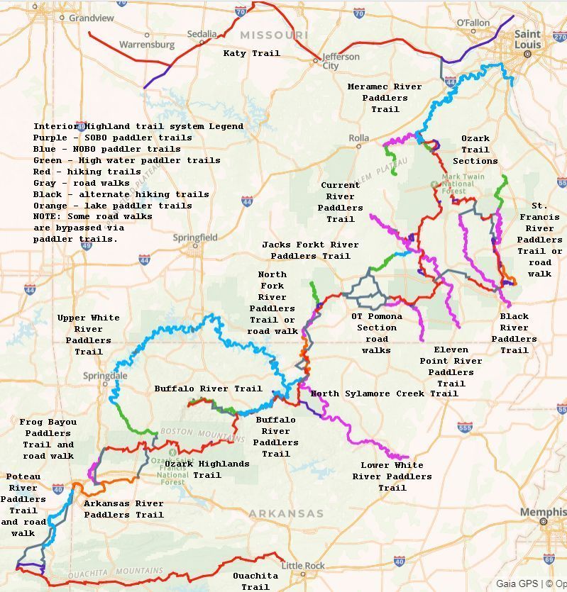
Katy Trail
The 350 mile Katy trail stretching from Kansas City to St. Louis along an old rail bed is not really in the Interior Highlands and can be part of a NOBO thru hike or you can bicycle its entire length.
Ozark Keystone Trail
The Ozark Keystone trail (AKA the Trans-Ozark trail) when completed will be 79 miles long stretching from the norther arm of Norfork Lake in Missouri to the Norfork Lake Dam in Arkansas. Portions of the trail name David's trails are complete. Alternatively you can paddle Norfork Lake to connect between the Boundary Waters section of the Ozark Trail and the Sylamore section of the Ozark Highlands trail. The planned GPS track is shown in the map.
OHT East Section
This is an gap in the Ozark Highlands trail connecting the Buffalo River trail at Dillards ferry and the Sylamore sections. The planned GPS track is shown in the map.
Ten Mile High App
Become a Member
The Ten Mile High is your digital guide to the Interior Highlands outdoors with downloadable route guides, outdoor maps, and powerful GPS navigation features. Our mobile app Android smartphones. Become a member!
U.S. Interior Highlands Hiking and Paddlers' Trails maps provided herein can be viewed and followed using the Ten Mile High App running on your smart phone. The App also provides social media so that you can report on trail conditions and learn of trail conditions reported by others.
No Phone Signal Required
Access to your routes and maps, even when there is no Internet. Ten Mile High GPS navigation works offline anywhere in along the trails in Missouri, Arkansas,and Oklahoma without phone or data coverage. Simply save maps and route guides to your device before you leave home.
See the App page for instructions on the use of the App.
The best app for hiking, walking, cycling, mountain biking the Interior Highland trails system and much more.
Once you have the Ten Mile App in hand then for a nominal fee you will receive GPS routes and waypoints of 32 loop hikes that adjoin the major trail sections. For additional fees you can receive GPS routes and waypoints of each of 60 major hiking and paddling trail sections.
Included are route descriptions for combined hiking and paddling loops trails and Great Circle trails. For example you follow the 658 mile OT SCENIC RIVERS HIKE AND PADDLE GREAT CIRCLE TRAIL where You will hike all 410 miles of the OT except the OT North Fork section and You will float 174 miles of the Meramec, St. Francis, Eleven Point, Jacks Fork, Current River, and Courtois Creek and visit all three of Missouri's National scenic rivers.
DISCLAIMER: Route and way point accuracy
Vehicle Navigation Systems and GPS units may provide inaccurate information in the Ozarks-sending drivers the wrong way on one-way roads or leading them to dead ends in remote areas.
Preparation
You must prepare for any hiking and paddling trek. Here we provide notes regarding Emergency Services and a list of Minimum Required Gear for single day and multi-day outings as well as camping guidelines and some of the possible dangers you may encounter and be on the watch for.
The Interior Highlands Trails
The Ten Mile High App is an aid not a crutch. We have provided all the GPS tracks with description including topographic maps and river maps with fully documented waypoints and ancillary information. Using the GPS features of your smart phone you will know where you are located and what features are in your future. Be prepared to fallback on the paper topographic maps and other printed documentation in the situation when the smart phone aid fails you!
The Interior Highlands Great Circles
The great circle trails combine hiking and paddling ranging from 658 miles to 20 miles in length. For example:
Scenic Rivers Hike and Paddle Great Circle Trail
- 658 mile Hike and Paddle starting on the Meramec River at Meramec Spring Park and ending on the Courtois Creek at Ozark Outdoors landing
- This is a late spring only hike and paddle or year round with good water.
- You will hike all 410 miles of the OT except the OT North Fork section
- You will hike over Missouri's tallest peak, view Missouri's tallest waterfall, bivouac in shelters built by the CCC in the 30's, see old grist mills built in the 1800's
- You will float 174 miles of the Meramec, St. Francis, Eleven Point, Jacks Fork, Current River, and Courtois Creek
- You will visit all three of Missouri's National scenic rivers
- 60 miles of road walk are involved
- Figure 60 days if you don't laze around fishing and swimming.
Pay It Forward
Clambering over fallen trees is not fun nor is picking your way down washed out trails at the risk of spraining an ankle. If you enjoy these trails and rivers they must be maintained and cleaned up. Pay it forward, be a Trail Maintenance/Construction Volunteer with one or more of the many organizations that have taken the responsibility for the particular hiking and paddlers' trails. Particularly, the OTA and OHTA needs volunteers to close the Keystone section gap and the OHTA needs volunteers to close the OHT east section and BRT gaps.
James Baughn Pavement Ends Blog
These are great hikes in Southeast Missouri and Southern Illinois to introduce young children to the outdoor experience. The author along with wife and his daughters have hiked nearly 60 % of these trails. Hiking to the Vortex in Illinois was spooky.
Ten Mile High Pavement Ends Blog
Look for similar map and blogs like James Baughns' from David Epps and other authors detailing short trails and Points of interest in Southwest Missouri and Northwest Arkansas.

Who We Are
David Epps, the founder of Ten Mile High, hiked many miles of the Appalachian trail, Missouri Ozark Trail, Arkansas Mt. Magazine trail, trails in Rocky Mountain National Park, and climbed to the summit of Longs Peak in Colorado. David Epps rafted (paddle and oar powered) the Colorado (Cataract Canyon, Westwater), Green (Gates of Ladore) , North Platte, Yampa (inflatable kayak), and Arkansas (Royal Gorge) rivers in Colorado, including through the Grand Canyon.
David Epps has canoed the Current, Eleven Point, and Jacks Fork rivers entire length in southern Missouri and many other rivers in Missouri, to include the Black, St. Francis, Huzzah, and Gasconade rivers, and busted the rapids of the Ocoee River in Tennessee and rafted the Motu River in New Zealand.
Others making up our team are
- Ann Wetherington - Documentation Specialist, Ten Mile High, LLC
- Beta Epps - Graphic Artist, Ten Mile High, LLC
- Lani Bleil - Photographer, Ten Mile High, LLC